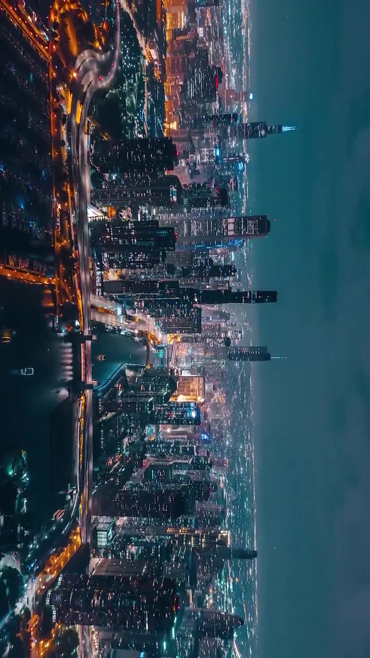
THE AERIAL CITYSCAPE — A LIGHTS SHOW POST SUNSET
From 300 feet up, cities hum beneath a blanket of stars, but the sky isn't dark as you might expect. Streetlights, buildings, and traffic trace the streets with car headlights forming a web of light. The view from a helicopter shows the city is not just buildings but the sum of its parts, especially the lights that signal its energy. The aerial cityscape after dark isn't just a view; it's a temporary light display that can't be seen from the ground. It's an interplay of architecture and energy that creates a fascinating panorama. The patterns of light that the buildings, roads, and waterways give off create a unique display every night. Whereas the night sky reveals the constellations, urban landscapes unveil the city's vast network of structures.
THE URBAN GLOW — YOU CANNOT SEE IT FROM BELOW
The urban glow, as scientists have called this display, isn't just about aesthetics. It reveals how cities operate at night. Many cities are designed to optimize public transport, energy efficiency, and more. The aerial cityscape is a live, time-lapse display of a city’s operational structure and the interaction of urban life. Many of the aerial cityscape scenery has seen a growing interest in aerial photography. The drones have made it easier to capture images from this height. The images are becoming much better at showing details and shade. The rapidly decreasing prices of drones has led to many more people exploring the aerial perspective.
A TALE OF LIGHTS AND LIFE
THE AERIAL POV
From this height, you can see entire neighborhoods in a single glance—like islands of light, separated by dark streets and less inhabited areas. If you watch any city's aerial display over time, you see the city's heartbeat. The lights change in a pattern that tracks the way people live and work within the city. The city starts to light up as 9-to-5 jobs finish, and the rush hour happens. You can even see the way people move, and where they move to when they go home.
PIXELS IN THE SKY
The megapixels in the modern drones’ cameras have been increasing rapidly. The aerial images of the city are getting impressively more detailed and precise. These projects, often done by artists or urban photographers, reveal the beauty of the city in a new light. Roads are more visible, and streets start to look like streams of blood. The city is highlighted in its full glory. The lights twinkle through the windows of buildings.
YOU NEED MORE THAN A GOOD CAMERA
The realistic photographs are a result of a good camera, a drone that can reach the required altitude, and an understanding of the weather and wind dynamics. If you want to get a consistent aerial map of the cityscape, you would need more than a good camera—you would need to be computationally sound. The images are a result of combining algorithms to stitch together images, and satellite images to create a meld of the two perspectives.
TH AN ASPIRING PHOTOGRAPHER'S GUIDELINES
The aerial photographer starts with a stable drone—one that can fly steady and capture the images. The best way to get the aerial cityscape images is not from mid-day light but from the twilight. It is important to plan your flight path beforehand. If you have a commercial license, you can capture images from even higher altitudes.
- Equipment: A stable drone and a premium camera is the minimum equipment required. Make sure you have enough batteries to capture the images—dronel flight time can be sometimes. If you want to capture night cityscapes, you can mount a thermal camera.
- Safety: If you are a beginner, try to avoid flying directly over the buildings. Make sure you also check for the no-fly zones in the area.
- Drive Planning: When you are planning a drone flight, make sure to check the weather and wind patterns. Also, know your path beforehand. It is important to have the path and the starting and landing area, but it's also important to make sure where you are going.
- Software: Master the drone flight software, stitching algorithms, and most importantly—image filtering.
Questions readers ask
What exactly is an aerial cityscape and why is it so unique?
An aerial cityscape is the view of a city from a high altitude, typically around 300 feet, that reveals a mesmerizing display of lights and shadows. This view is unique because it shows the city's operational structure and the pulse of life, which can't be seen from the ground. It's more than just a pretty sight; it's a live snapshot of how a city functions at night, with lights from buildings, streets, and traffic creating intricate patterns.
How does the urban glow help us understand cities better?
The urban glow provides valuable insights into a city’s operational structure and energy efficiency. It shows how cities are designed to optimize public transport, energy use, and more. By observing the aerial cityscape, you can see the city's heartbeat—how different areas light up and change throughout the night, reflecting the daily rhythms of its inhabitants.
Can anyone capture aerial cityscape images, or is it a job for professionals?
With the increasing availability and affordability of drones, anyone can capture aerial cityscape images. However, to get high-quality, detailed shots, you need more than just a good camera. You also need a stable drone, an understanding of weather and wind dynamics, and computational skills to stitch together images and create a coherent aerial map.
What kind of equipment do you need to capture detailed aerial cityscape images?
To capture detailed aerial cityscape images, you need a high-quality drone with a good camera, preferably one with rapidly increasing megapixels. You also need a drone that can reach the required altitude and fly steadily. Additionally, understanding weather and wind dynamics is crucial, as is the ability to use algorithms to stitch together images and create a melded perspective with satellite images.
How has drone technology changed the way we see cities at night?
Drone technology has made it easier and more affordable to capture aerial cityscape images, revealing details and shades that were previously hard to see. With drones, you can see entire neighborhoods in a single glance, track the way people move within the city, and create impressively detailed and precise images that showcase the city's beauty in a new light.
Related deep dives
Similar reads based on topic and creator.




Recent articles
Fresh deep dives from the latest Reels we unpacked.


Comments
Be the first to comment.