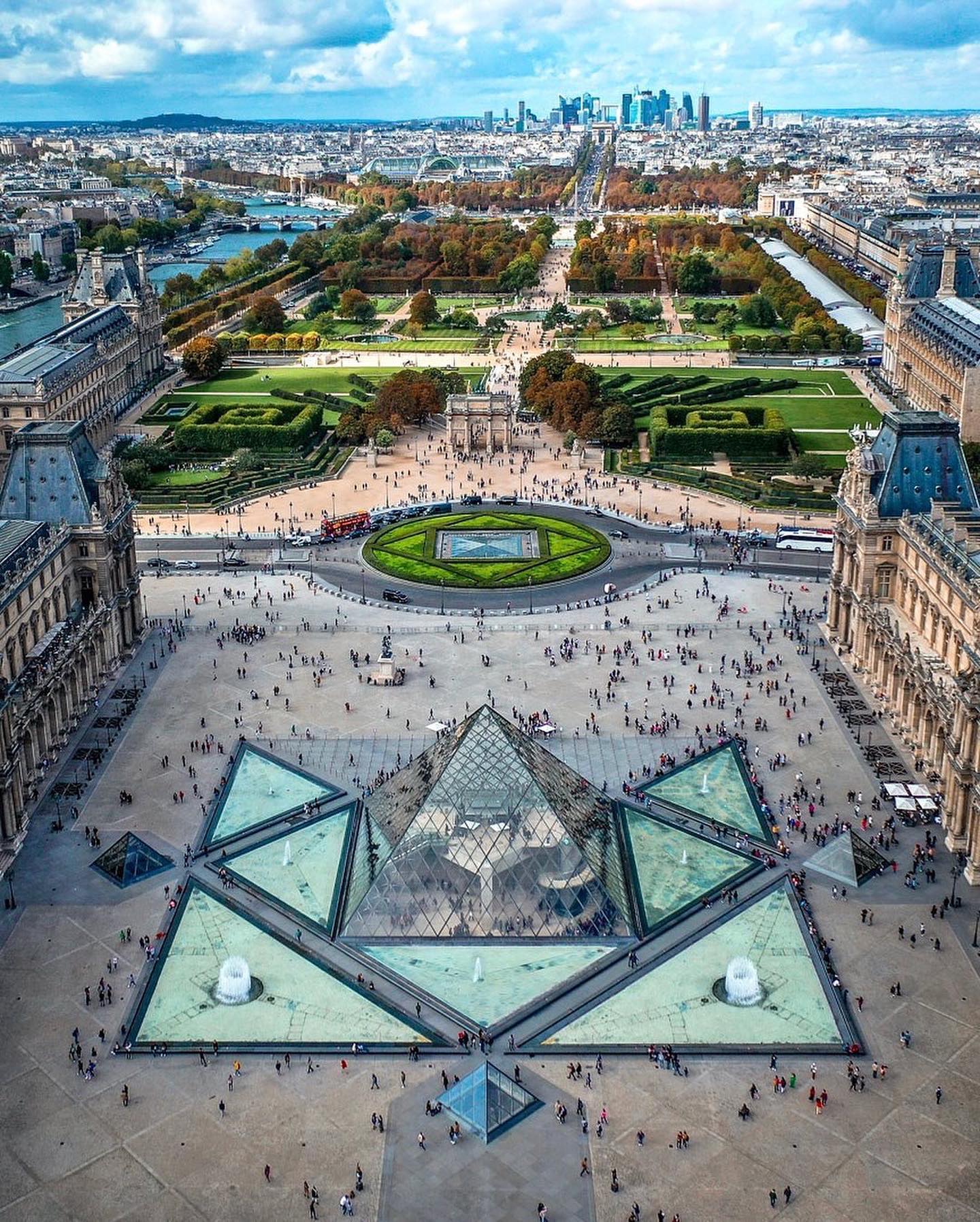
Aerial Views of France: Seeing New Heights
A sprawling view of France from above reveals iconographic landscapes twining past and present. The…
In the Clouds with France's Panoramic Skyline
Aerial photography is a unique perspective that captures the essence of a location from above. In France, aerial views provide a dramatic look at both well-known landmarks and unseen details. France's aerial views are distinct because they highlight the contrast between ancient and modern architecture. Cities like Paris and Lyon offer a blend of historic buildings and contemporary structures, making them perfect subjects for overhead photography. The visual harmony of old and new creates a rich tapstry that tells a story of France’s evolution. Aerial photography in France often involves capturing iconic landmarks from a unique angle. Instead of looking at these sites from street level, aerial views offer a bird's-eye perspective that reveals intricate details and the surrounding landscape. For example, the Louvre Museum in Paris is made iconic by its glass pyramid surrounded by the Tuileries Garden and Place de la Concorde. From an aerial perspective, the Louvre's pyramid stands out against the jumble of the city.
The Travel Perspective: Exploring the French Skyline
A huge appeal of aerial views in France comes from the power of travel. More than just a postcard, aerial shots offer tourists a way to see the country's beauty from a new perspective. By capturing the essence of France from above, aerial photography provides a travel experience that is both breathtaking and educational. Each new view presents a chance to see the well-known and hidden gems of France. France’s aerial views underscore the glory of the country's natural and built environments. They reveal how French geography and infrastructure have shaped the landscape, from urban metropolises to coastal towns. For instance, the harbor in Marseille features a striking marina dotted with yachts and boats, framed by the city skyline.
A Panoramic Paris
The aerial perspective of Paris highlights how the city has evolved over centuries. Iconic landmarks like the Louvre Museum, the glass pyramid, and the Tuileries Garden become part of a larger canvas, where gardens and parks offer a green respite from urban life. An aerial view frames the Louvre as part of a broader urban landscape, making it just one element in a larger scene. This perspective shows how Paris has managed to preserve its historic heritage while embracing modernity. Luxury at its apex, the aerial perspective offers a dynamic way to appreciate the diversity of French architecture. The combination of old and new buildings makes the city's aerial shots incredibly picturesque. Tourists can see how iconic landmarks like the Louvre Museum blend seamlessly into the surrounding urban landscape, offering a new way to appreciate the city's rich history. Waterfronts and beyond, aerial photography captures France’s maritime heritage with vivid clarity. The Marseille harbor, for example, with its large marina filled with yachts and boats, is a visual feast from above. Far from just a docking ground, it becomes part of a larger narrative of the city’s relationship with the sea. Similarly, the panoramic view of a French coastal town reveals a charming scene, with a nestled harbor, surrounding hills, and a historic fort – a reminder of both the past and present.
From Suffolk to Alaska
In contrast with France, these two aerial perspectives emphasize different angles of its identity. Suffolk, England is known for its rolling green hills and pastoral landscapes, while Alaska by contrast boasts an entirely different kind of grandeur. Suffolk's charming countryside offers a serene escape from urban life. The aerial views of this region are dominated by rolling green hills and quaint villages, providing a stark contrast to France’s urban landscapes. The aerial photography of Suffolk emphasizes the beauty of rural life, with fields and forests stretching out in a tranquil expanse. Alaska’s rugged terrain, on the other hand, showcases breathtaking natural landscapes and rugged terrain. From the dense forests to the snow-capped mountains, these views capture the raw, untamed beauty of the region. It provides a stark contrast to the ordered cities of France, emphasizing the vastness and untouched beauty of the natural world.
Simulating Drone Flight
To create a compelling aerial photography in France, begin with aerial photography basics. These shots require a drone with a high-quality camera and, ideally, a gimbal to stabilize the footage. Before flying, check local regulations and obtain necessary permits.
- Preparation: Plan your route well. Use mapping tools and apps to plan the best flight paths and shooting locations.
- Technical proficiency: Mastering drone controls is crucial. Learn how to maneuver smoothly and maintain a steady altitude.
- Weather check: Always check the weather forecast. Clear skies and stable weather conditions are best for aerial photography. Post-production adds the final touch to aerial shots. Use software like Adobe Lightroom or Adobe Photoshop to enhance the colors, contrast, and detail in your photos. Pay attention to composition: ensure your subject is well-framed and that the play of light and shadows enhances the overall look. Safety first is the mantra of drone photography. Always fly within visible range and avoid flying over crowds or sensitive areas. Follow all local drone regulations to ensure a safe and legal flight.
French skies above
Aerial views of France are more than just picturesque snapshots; they offer a unique perspective on the country’s rich tapestry of landscapes and architecture. Whether it’s Paris featuring the glass pyramid or Marseille boasting its harbor, aerial photography captures the essence of France in a way that ground-level views cannot match. The combination of natural beauty and urban charm makes aerial France a captivating subject for photography enthusiasts and travelers alike. So the next time you're in France, consider looking up to see a whole new world from above.
Questions readers ask
What kind of architecture do aerial views of France typically highlight?
Aerial views of France often highlight the contrast between ancient and modern architecture. Cities like Paris and Lyon show a blend of historic buildings and contemporary structures, offering a unique perspective that tells the story of France's evolution. This contrast is particularly striking in aerial photographs, where the harmony of old and new creates a rich tapestry.
How do aerial views differ from traditional photographs when capturing iconic landmarks?
Aerial views provide a bird's-eye perspective that reveals intricate details and the surrounding landscape, unlike traditional street-level photographs. For instance, the Louvre Museum in Paris is made iconic by its glass pyramid, which stands out against the urban jumble when viewed from above, offering a more comprehensive and dramatic look at the landmark and its setting.
What makes aerial photography a unique travel experience in France?
Aerial photography in France offers a unique travel experience by providing a new perspective on the country's beauty. It allows tourists to see well-known landmarks and hidden gems from above, making it both breathtaking and educational. Each aerial view presents a chance to appreciate France's natural and built environments in a way that's different from traditional sightseeing.
Can aerial views help in understanding France's urban and natural landscapes?
Yes, aerial views in France underscore the country's natural and built environments, revealing how geography and infrastructure have shaped the landscape. For example, the harbor in Marseille, with its marina and city skyline, provides a clear view of the urban and coastal landscapes, showcasing the country's maritime heritage and infrastructure.
How does an aerial view of Paris differ from a ground-level view?
An aerial view of Paris highlights the city's evolution over centuries, framing iconic landmarks like the Louvre Museum as part of a larger urban landscape. This perspective shows how Paris has managed to preserve its historic heritage while embracing modernity. Ground-level views, on the other hand, offer a more detailed look at individual landmarks but may not provide the same sense of the city's overall layout and development.
What are some of the most striking aerial views in France besides Paris?
Besides Paris, aerial views of cities like Lyon and Marseille offer unique perspectives. Lyon's blend of historic and modern architecture, and Marseille's harbor with its marina filled with yachts and boats, provide striking aerial views that showcase the diversity and beauty of France's urban and coastal landscapes.
Is aerial photography in France only about capturing landmarks, or does it show more?
Aerial photography in France captures more than just landmarks. It reveals the intricate details of the surrounding landscape, the harmony between ancient and modern architecture, and the natural beauty of the country's geography. For instance, aerial views of the Louvre Museum also show the Tuileries Garden and Place de la Concorde, providing a more comprehensive understanding of the area.
Related deep dives
Similar reads based on topic and creator.


Recent articles
Fresh deep dives from the latest Reels we unpacked.



Comments
Be the first to comment.