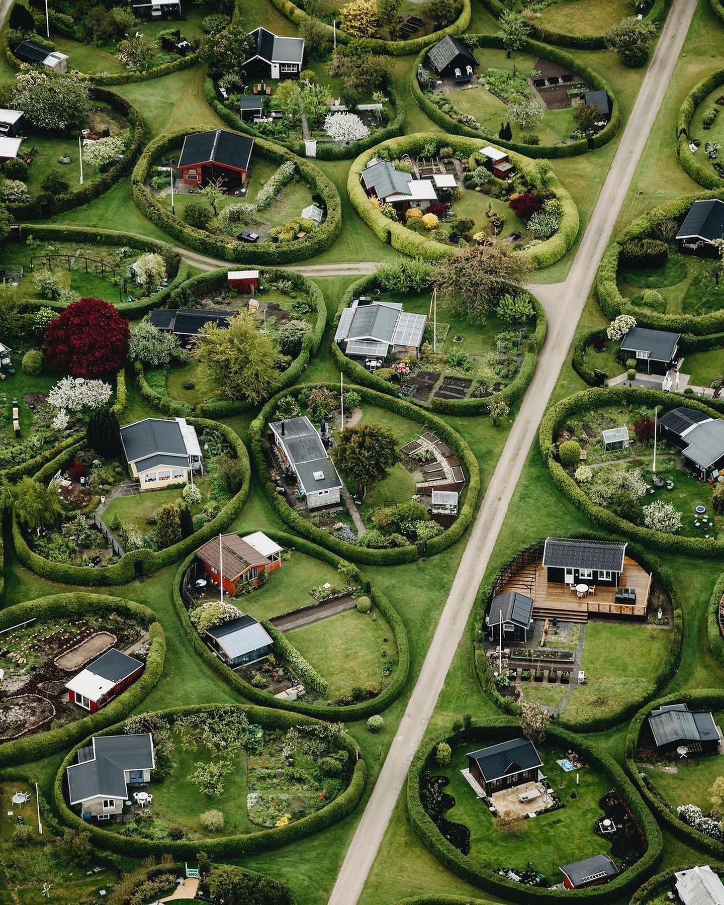
Urban and Village Aerial Views
About two-thirds of the world's inhabitants live in urban areas, and an additional half a million will move to cities every year. Our aerial view moves into the English countryside — to a rustic village— as well as busy European cities to reveal a world both stunning and serene. Each aerial view gives a sense of how communities are structured and how humans share space.
The Aerial Perspective
The aerial perspective is a unique way to view structures, and offers both a spatial overview and a detailed look at the architecture. Unlike the ground view, aerial shows a home’s positioning within the village, the spacing between houses, and the landscape layout surrounding the house. Similarly, in European cities, the aerial perspective reveals the dense packing of buildings and the uniformity of design. The aerial view makes it easier to appreciate the unique landscaping style of the village and the architectural cohesiveness of the European city. The typical aerial view uses the horizontal axis of the roofs to guide the eye, emphasizing the layout of the buildings. This perspective allows viewers to appreciate the beauty and organization of rural and urban landscapes, something that's not visible on the ground.
How aerial views show us how we live
Today's aerial views aren't just for the weekend Instagram post — they reveal the changes and challenges of life in the modern world. The aerial perspective can be a tool for urban planners and architects to better understand the layout and design of cities and towns, and to make decisions based on the data.
Rural Life, Revealed
Aerial shots showcase the unique landscaping style of the village, even the circular gardens surrounding each house. Traditional village houses sit close to each other with winding paths connecting the houses. The aerial view allows us to appreciate rural architecture and its relationship with nature. This type of village layout suggests a close-knit community, where neighbors are nearly face-to-face.
Urban Pattern Rules
Eye-level photography highlights the complexity and density of a European city. In Europe, cities are packed with tightly packed buildings and streets. These places generally follow a grid-like street layout. The aerial view highlights the central square with a tree — a focal point that adds visual interest and a sense of order. Instead of natural elements, the geometry of the buildings and streets creates a striking pattern. The aerial perspective provides a unique view of the city, showcasing the density and complexity of urban life. European cities often have a central square with a tree, adding a focal point to the urban landscape.
Aerial Flight Bans and Picture-By-Pictures
The bird’s-eye view can capture a breathtaking scene, but is often forbidden in some countries. In the United States, some cities have banned drones or made them restricted, while in Europe, drone regulations are stricter. It's impossible to create a timeline of the world's aerial views, because most are droneless and stallant. Each aerial image is just a single moment, a glimpse of a place in time. There's virtually no way to record the entire transition; only static pictures remain. For example, an aerial shot on Google Maps helps a viewer to see the architectural design and the landscaping style of a village or a city. Airlines have started using drones to capture aerial views of their fleet and airport facilities, to better understand the layout of their facilities. This way, airlines can make better decisions about their operations and improve their efficiency.
The Evolution of Aerial Perspective
The aerial view is nothing new; photographs of cities and villages have been taken since the 19th century. However, the advent of the drone camera has made aerial photography more accessible and easier. This technology has allowed to capture stunning aerial views that were previously impossible to achieve. Additionally, the rise of high-resolution cameras and image processing software has enabled to create detailed and accurate maps from aerial photographs.
Your Own Aerial View
- Designate a Spotting Partner: Find a drone expert or a local who can spot a good aerial location
- Preflight Check: Ensure that all drone regulations are followed, and that the drone and batteries are fully charged and ready to go.
- Survey the Area: Use a map to survey the area and find the best aerial spots. In rural villages, look for high points and interesting architectural and landscaping features. In cities, look for central squares, parks, and unique buildings. As drones become more affordable, more people are able to capture aerial views.
- Check Local Regulations: Many countries and cities have drone regulations, so you must check and make sure you comply with the drone laws of the area before you fly.
Questions readers ask
What makes aerial views of European villages and cities so unique and revealing?
Aerial views offer a unique perspective that shows the spatial layout of buildings and landscapes, as well as the architecture and design of villages and cities. The aerial perspective allows you to see how communities are structured and how humans share space, which is not visible from the ground. Additionally, aerial views can reveal the unique landscaping style of villages and the architectural cohesiveness of European cities.
What is it about the aerial perspective that makes it so valuable for urban planners?
The aerial perspective provides a spatial overview and a detailed look at the architecture, which can be valuable for urban planners and architects. It allows them to better understand the layout and design of cities and towns, and to make decisions based on the data. This perspective also highlights the density and complexity of urban life, which can be useful for planning and development.
What are circular gardens and why are they unique to the English countryside?
Circular gardens are a unique landscaping feature found in the English countryside. They are typically circular in shape and surround each house, creating a distinctive and charming landscape. These gardens are not typically found in urban areas, and they add to the rural charm and beauty of the English countryside.
What is the significance of the central square with a tree in European cities?
The central square with a tree in European cities serves as a focal point, adding visual interest and a sense of order to the urban landscape. It creates a striking pattern and highlights the geometry of the buildings and streets, which is a unique feature of European urban design. This central square is a common element in European cities, and it adds to the overall beauty and organization of the urban landscape.
Why are drone regulations stricter in Europe compared to the United States?
Drone regulations in Europe are often stricter due to concerns about privacy, safety, and security. This is why some cities have banned drones or made them restricted. In contrast, regulations in the United States can vary by city and state, with some places having more lenient rules. These regulations can impact the ability to capture aerial views, as drones are often used to take these photographs.
Can aerial views help us understand how communities have evolved over time?
Aerial views can provide a snapshot of a place in time, but they are not typically used to create a timeline of how communities have evolved. This is because most aerial images are droneless and stallant, making it difficult to capture changes over time. However, aerial views can still reveal the changes and challenges of life in the modern world, such as urbanization and rural development.
What are some of the challenges of capturing aerial views in urban and village landscapes?
Some of the challenges of capturing aerial views include drone regulations and the fact that aerial images are just a single moment in time. Additionally, capturing aerial views in urban areas can be challenging due to the density and complexity of the landscape, as well as the presence of tall buildings and other obstacles. In rural areas, the challenge may be finding the right vantage point to capture the unique landscaping style and architecture.
Related deep dives
Similar reads based on topic and creator.



Recent articles
Fresh deep dives from the latest Reels we unpacked.



Comments
Be the first to comment.