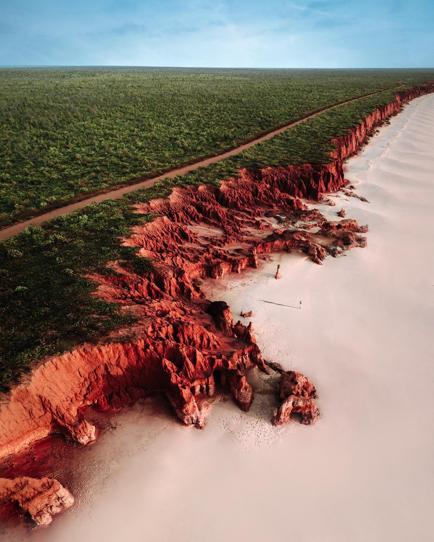
Drone cameras gave us bird’s-eye views that let us appreciate just how dramatically beaches meet cliff faces and rock formations. They have become an essential tool for capturing these awe-inspiring sights from above.
Coastal Aerial Photography: Seeing From Above
Aerial photography harnesses the power of flight to deliver a perspective that evokes wonder and reveals patterns invisible from the ground. The unique geographical features of coasts—where sea meets land—make for particularly striking compositions. This is defined not just by distance above land, but by the equipment used. Most drones can hover steadily and stay in position to provide shots of geological features on the coast — some hunt for cliffs, beaches, or rocky formations for a striking contrast. While coastal aerial photographs often feature rugged beauty, the medium's distinctive asset is its form of motion: it captures not just the place, but the experience of sweeping across it. For example, many coastal aerial photographs feature a lone figure, usually a human propped on a narrow peak or walking along a beach, to emphasize the scale of the landscape. Understanding the landscape and our place in the world often involves an element of seeing from above. It's not different for aerial photography. The human body feels natural on footpaths. However, a drone gives a new view that significantly enhances our experience of natural landscapes. We can see the sharp distinction between coastal landforms, such as the red cliff and white sand, and the ocean far below from miles above. The photos often turn out to be a unique document of a certain place because of how they celebrate detail at large distances.
Making The Most of Coastal Geographical Features
From the perspective of photographers, coastal geography is so unique, thanks to its sudden, contrasting features. For this reason, many striking photographs capture a clear contrast between white, sandy beaches and towering, red cliffs—like a turquoise water that glances off the rocks. This contrast is not just a striking visual detail. It also brings attention to the forces of nature that shape our planet to such detail. The climate and geological features at these coasts often say a lot about the region.
Changing photographic perspective
While coastal landscapes have always been a favorite subject for photographers, capturing them from above has changed the way we appreciate them. Coastal geology has been highlighted dramatically by aerial photography. For example, an aerial perspective allows us to see how layers of rock have been shaped over millions of years, giving us insights into the geology of these regions. This experience is closely related to our sense of scale, wonder, and curiosity about the world. The photographer captures the essence of the landscape from above with a drone, and this offers an immersive experience when the drone allows the photographer to capture the landscape from above. It can be a unique experience when the drone brings the film perspective from above. Using drones to capture the beauty of our world is a game changer for photographers. In essence, we can expect more coastal aerial photos to be shared as these devices become more accessible and affordable.
The Impact of Technology: A New Era in Accessibility
The evolution of aerial photography didn’t just happen on wings. Instead, this craft owes its rise to advancements in technology, such as drone photography. The compact, portable nature of drone cameras has made aerial photography more accessible. This democratization of the camera has allowed budding photographers to experiment with angles and perspectives that were previously only available to professionals or enthusiasts with access to helicopters or planes. Drone technology has made it possible to capture aerial shots with high quality and precision, opening a whole new world of possibilities. The accessibility of these devices also makes space for a lot of creativity, as users can experiment with different angles and perspectives to capture unique and breathtaking views of the landscape.
Drone Cameras and Precision
Drone cameras have made it easier to capture aerial views with precision and accuracy. They can be controlled remotely and powered by AI to hover steadily over a specific location, providing a stable and clear image of the landscape. The contrast between the red cliffs and white sand makes the photographs visually striking, allowing photographers to capture the beauty and detail. The turquoise water adds to the visual depth and dimension of the coastal landscapes. The turquoise water adds to the overall beauty of the coastal landscape. The contrast between the red cliffs and the white sand creates a visually striking scene. The geological formations are highlighted, making the photographs even more impressive. To top it all, the turquoise colour of the water adds to its beauty, making it a must-see in coastal aerial photography.
When Aerial Meets Art
Aerial photography often captures the natural geological features of the coast, taking its artistic value to a whole new level. This is seen as it features rugged beauty and picturesque locations. Coastal aerial photography captures geological formations and presents them in a new light, showcasing their natural features and the beauty of the landscape. This makes aerial photography a powerful tool for conservation and environmental awareness. The natural features of the coast are often a striking contrast to the human activities happening around it. By bringing it into the spotlight, aerial photography can raise awareness of these issues and promote conservation efforts.
Capture The Best Coastal Sceneries
If aerial photography sounds like something you'd like to try, it's simpler than you might think. Anybody can use a drone to capture stunning shots. Coastal aerial photography provides a unique and immersive experience. While there are specialized techniques that professional photographers use, such as the perfect weather conditions and camera settings, most droning companies tend to offer beginner kits that are easy to operate, so you just need to follow a few steps for the best shots. A few practical tips to keep in mind:
- Weather Conditions: While a drone can function in most weather conditions, the best shots are achieved when skies are clear, and the weather is calm.
- Know the landscape: Most coastal aerials are beautiful because of the contrast. Learn about the different landscapes of the coasts you plan to visit. This will not only make you more aware of the different features but also prepare you for the best shots.
- Local drone laws: Understand and respect local laws. Each coastline has its laws regarding where drones can fly. Marine protected areas and military zones are just a few of the many places where drones are banned.
- Stay safe: Avoiding flying over busy beaches is a good idea for drones, which can be considered invasive. Respecting the privacy of others and keeping a safe distance are essential when using a drone. Coastal aerial photography is widely available. Anybody with a drone can capture images from the sky.
Questions readers ask
What kind of drones are typically used for coastal aerial photography?
The article doesn't specify particular drone models, but most drones used for this purpose can hover steadily and stay in position. This capability is crucial for capturing detailed shots of geological features like cliffs, beaches, and rocky formations. The key is the drone's ability to provide a stable, bird’s-eye view of the landscape.
How does aerial photography help us understand coastal geology better?
Aerial photography provides a unique perspective that reveals geological features and patterns invisible from the ground. For instance, it allows us to see how layers of rock have been shaped over millions of years, offering insights into the geology of coastal regions. This aerial perspective enhances our understanding of the forces of nature that shape our planet.
Why do many coastal aerial photographs include a lone figure?
Including a lone figure in coastal aerial photographs serves to emphasize the scale of the landscape. By showing a human figure perched on a narrow peak or walking along a beach, the photographs highlight just how tiny we are compared to the vastness of nature, evoking a sense of awe and wonder.
What makes coastal aerial photography different from other forms of landscape photography?
Coastal aerial photography is unique because it captures not just the place but the experience of sweeping across it, thanks to the medium’s distinctive asset of motion. The contrast between coastal landforms, such as red cliffs and white sand, and the ocean far below, provides a unique perspective. This form of photography celebrates detail at large distances, making it a distinctive and immersive experience.
Can I use any drone for aerial photography, or do I need a specialized one?
You don't necessarily need a specialized drone, but it should have the ability to hover steadily and stay in position. This is crucial for capturing detailed shots of geological features. Many drones on the market today have these capabilities, making them suitable for aerial photography.
What kind of details can I capture with a drone in coastal aerial photography?
Drones can capture a variety of details, including the contrast between white, sandy beaches and towering cliffs, as well as the unique geological features that shape these landscapes. You can also capture the movement of the ocean, the texture of the cliffs, and the delicate balance of nature.
Related deep dives
Similar reads based on topic and creator.
Recent articles
Fresh deep dives from the latest Reels we unpacked.
Comments
Be the first to comment.