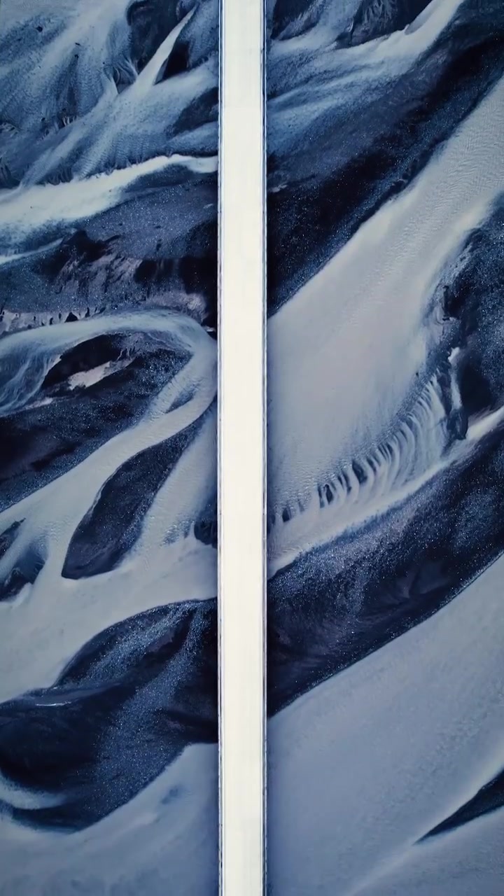
The Symmetry and Fractal Allure of River Aerials
The humble river. Take familiar sightings of it and shift just the camera angle, and the winding path unveils a vista as intricate as any that Lego layouts, cutaway maps, or soapstone carvings aspire to. As the the viewer floats unseen over a curvaceous river, the camera captures the the river's flow creating an organic pattern that is both distant and intimate, capturing the essence of riverscapes through the nuanced interplay of light and shadow.
Life at Eye Level Versus the Birds' Eyes View
Like stones on a beach, these aerial perspectives are an unavoidable, action-packed, nature documentary distraction. 100% eye candy, they raise several questions. How do we read them? Do we see the river itself differently from the view above? And what is the source of their near-mesmerizing impact? Drone videos allow for a greater understanding of river system dynamics. Bird's-eye views enable us to observe changes in river courses over time. This is how river features such as meanders, oxbow lakes, and braiding patterns can be explored. When watching a river from below, such as when you walk near the water, you will notice the constant oscillation of its surface. The video footage suggests that the constant undulating forms of water create an unending flow of visual information that gets lost in the details. Consequently, the eye doesn’t work in the aerial view to discard details the way it does from the ground. Unlike walking along a riverbank, where the mind can wander to some stirring sound and forget about the panoramic vista plays out before the eyes. Because the aerial view is like a giant add-on to the entire river landscape, the aerial view provides an entirely different experience to eyes used to 'ordinary' scales. This is because the aerial view prevents the eyes from creating a filter around the river and forces the viewers to see it as a whole. There is very little that is comparable to this kind of 'puzzle' view of the entire river bed, which simultaneously exposes the whole structure of the land and landscape.
On Understanding the River's Pathways
Reading the Etchings
An aerial view of a river shows the river's path as a winding, asymmetrical shape that gracefully weaves through the landscape. This is unlike the straight lines depicted on maps, where a river's path is greatly simplified. This asymmetrical shape has both emotional and aesthetic appeal. The ever-shifting shapes of the water's surface enable the development of visual curiosity.
The Path and the Flow
The river's path is not arbitrary. A river flows in a very organized way, distinct from a sea or lake. It has a clear 'source' and then flows towards a 'destination'. This makes it easier to study the river's journey, as it balances gravity, friction, and water flow. This is why every curve and bend is a story.
The Position of the Light
The river’s intricate patterns emerge not just from the flow of water, but from the interplay of light and shadow. The varying intensities and positions of the sun cast shadows that reveal the landscape’s contours more vividly. These shifting shadows create striking visual contrasts, highlighting the riverbed’s contours and the terrain’s undulations.
How the Curves and the Bends Work
It's due to their geometrical properties, curves and bends that in simple terms go by 'meandering'. As the river meanders between the banks, water moves faster in the outer bend and slower in the inner bend, causing deposition of sediments in the inner bend and erosion in the outer. The river continues to curve gently inward, forming another meander. Eventually it approaches the cut-off point and may eventually create an oxbow lake.
Seeing the Wider Panorama
The aerial view provides a panoramic perspective of a river, revealing how its path interacts with the surrounding landscape, such as a 'natural border' between two landmasses. This is useful for people who work with land surveying, hydrology, and civil engineering. It can even be used for educational purposes to guide people regarding land's geographical features.
Learning How to Make Sense of the Pattern
Visualizing the Course of the River
Aerial photography can be wonderful for much more than a casual viewer to just observe. One must "scan" the landscape rather than focusing on singular elements in it, as this allows the mind to piece together the whole, rather than being distracted by the pleasing river patterns.
Weighing the Drones' Relationship With Nature
As drones become cheaper and easier to use, it is imperative to understand one's ethical responsibilities towards them. Landscapes can remain pristine only if responsible drone operators and photographers share. Rather than acting intrusively, the owner should treat each landscape as a venue they would like to capture without harming it.
Questions readers ask
How do drones capture the fractal patterns in rivers?
Drones capture these patterns by flying above rivers and using their cameras to record the winding paths from a bird's-eye view. This angle reveals the intricate, organic patterns that are less visible from ground level, making the river's flow and contours more apparent.
Why do aerial views of rivers look so different from ground-level views?
Aerial views provide a holistic perspective that shows the entire river landscape at once, unlike ground-level views, which can be more fragmented. From above, the eye doesn't filter out details the way it does when walking along the riverbank, allowing for a more immersive and detailed experience of the river's structure.
What makes the aerial view of a river so mesmerizing?
The aerial view of a river is mesmerizing because it reveals the river's intricate, ever-changing patterns in a way that is both distant and intimate. The interplay of light and shadow adds to this effect, creating a visual experience that is both beautiful and thought-provoking.
How do aerial views help in understanding river dynamics?
Aerial views help in understanding river dynamics by showing how rivers change over time. From above, you can observe features like meanders, oxbow lakes, and braiding patterns, which are crucial for studying the river's path and flow. This perspective provides a clearer picture of how the river interacts with its surrounding landscape.
What is the significance of the river's path being asymmetrical?
The asymmetrical path of a river is significant because it reflects the natural forces at play, such as gravity, friction, and water flow. This path is not arbitrary; it tells a story of the river's journey from its source to its destination, making it both aesthetically pleasing and scientifically intriguing.
How does the position of the light affect the appearance of a river from above?
The position of the light, particularly the sun, affects the appearance of a river from above by casting shadows that reveal the landscape's contours more vividly. The varying intensities and positions of the sun create a dynamic interplay of light and shadow, enhancing the visual appeal and making the river's patterns more distinct.
Can I use drone footage to study the river's path and flow?
Yes, drone footage can be very useful for studying a river's path and flow. It provides a detailed, bird's-eye view that can help you observe the river's dynamics, changes over time, and the interplay of natural forces. This can be particularly valuable for environmental studies or educational purposes.
Related deep dives
Similar reads based on topic and creator.


Recent articles
Fresh deep dives from the latest Reels we unpacked.



Comments
Be the first to comment.